Byron Hikers Club Incorporated
Powered by
Events
Upcoming
Aug
01
Brummies Lookout. Saturday August 1st 2026
Flutterbies Cottage Cafe
09:00 – 15:00
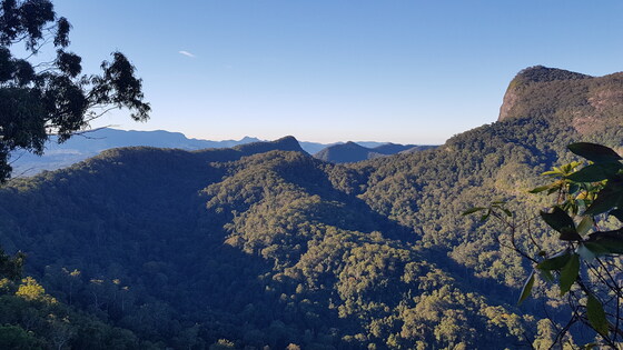
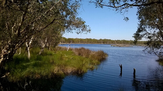
A pleasant half day walk to a lovely little peak on the inner caldera of Wollumbin. There are stunning and unusual views from the top of Brummies lookout of Wollumbin and into Cedar Creek (one of the many). Rumor has it that the cedar getters used to climb up here to spot cedars.
We meet at Flutterbies cafe in Tyalgum to car pool to the start of the walk (about 5min out of town) with coffee and lunch options in Tyalgum before and afterwards.
The walk is a steep uphill on a firetrail followed by an even steeper uphill section of single track path involving a little scrambling. It requires a good level of cardiovascular fitness and leg strength for the down hill.
Bring the usual, hat, water, snacks and comfortable footwear (sandshoes or boots)
Grade 3 Leader David Froggatt 0402 470 546
Aug
08
Billinudgel Nature Reserve Loop (Northern Section) Saturday 8 August
Jones Road
08:30 – 14:00
Join us for a relaxed morning walk exploring one of the quieter and lesser-known natural areas of the Byron Shire.
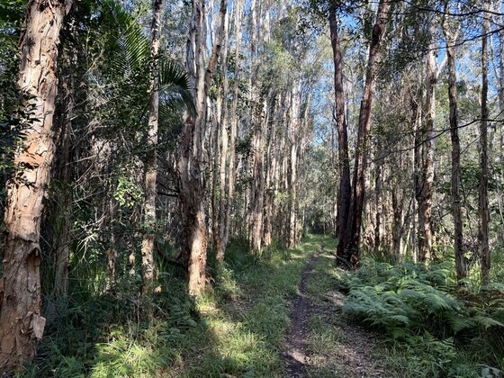
Beginning at Jones Road, we’ll follow the Quarry Trail through open eucalypt forest before joining the Central Trail, where we’ll wander beneath stands of ancient cypress pines and paperbark forest. This diverse reserve provides a wonderful opportunity to experience the changing vegetation and enjoy the peace of the bush.
From the forest we’ll emerge onto New Brighton Beach, following the shoreline north behind the dunes with expansive coastal views and the chance to spot seabirds and marine life. Before Wooyung Beach Holiday Park we’ll turn inland, passing the site of the former Splendour in the Grass festival before returning to Jones Road to complete the loop.
This is a mostly flat Grade 3 walk with plenty of opportunities to appreciate the area’s rich natural diversity, making it ideal for walkers who enjoy a leisurely pace and time to soak up the surroundings.
Distance: approximately 10 km
Grade: 3 (mostly flat)
Finish: lunchtime/early afternoon
Leader: David Roland Email: david@davidroland.com.au
Aug
15
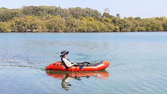
Paddle Ukerebagh Island Saturday 15 August, Tweed estuary
Water Street
09:00 – 12:00
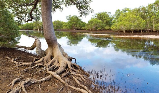
Located at the mouth of Terranora Inlet in Tweed Heads, this is a great place to see coastal mangrove, saltmarsh and rainforest. The area is of special importance to the local indigenous community. Expansive vistas on the open water of the river combine with hidden corridors that harbour marvellous creatures to make this an endlessly exciting paddle trail.
A paddle around the island takes around 2 hours. We will leave at high tide 9am so as to avoid paddling against the current as tidal flow can be strong in the Tweed River.
Kayaks will be launched from Water St off Minjungbal Drive - be prepared to carry them a short distance to the sandy beaches.
Once around the island we can continue up Terranora Creek or else do the ‘walk on water’ at Minjungbal Aboriginal Museum and and Cultural centre https://minjungbalmuseum.com.au/
Own kayak required or you can hire from Endless Summer SUP & kayak hire or Watersports Tweed on Kennedy Drive. Grade 3, need to be comfortable in a canoe due to current.
Leader Sandy 0415 239 620 sandylpimm@gmail.com
Aug
22
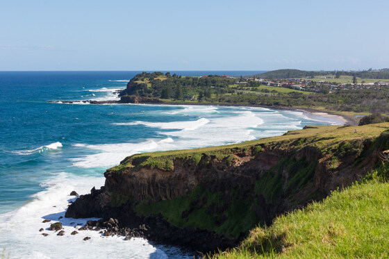
Sharpes Beach to Lennox Head and Return 22 August 2026
Lennox Head
08:30 – 15:30
Varied and relaxed coastal walk on grassy headlands, beaches and littoral forest. Spectacular views and possible whale sightings. Approximately 13km. Grade 2-3
Bring water, lunch and snacks ( option of getting lunch or coffee in Lennox Head), sun protection and swimwear if you enjoy a winter dip
leader Paula 0427667791
Sep
13
Paddle Evans River Sunday 13 September
Boat Ramp - Paddon Memorial Park
09:00 – 14:00
Paddling upstream from the boat ramp on the southern side of the traffic bridge in Evans Head , the outside world will melt away as you pass river islands, mangroves, rainforest as well as heathland and coastal banksia. A birdwatching paradise, listen for the distinct call of the eastern whip-bird and the toy trumpet like call of the rare barred cuckoo shrike. You might glimpse shorebirds such as the white faced heron or pied oystercatcher. At dawn and dusk, eastern grey kangaroos, red-necked wallabies and swamp wallabies often come out to feed. Scour the tops of nearby trees and there could be a sleeping koala or two.
We pass Gummigurrah picnic area which was an important winter camp site for traditional owners, as well as the 'iron gates' a natural rock formation damaged by flood mitigation works but where you still may see some upwelling.
Maximum 5 hour paddle aiming for the Evans golf course but depending on how far people are comfortable paddling we can turn around early.
Own canoe or kayak required, or you can hire from Evans Head Surf Shack or Evans Head Small Boat Hire.
Easy Grade 2.
Leader Sandy 0415 239 620 sandylpimm@gmail.com
Sep
18
Evans Head Chinaman's Beach Thur Sep 18
08:00 – 14:00
Some beach and some heathland, maybe some wild flowers in Spring.
Grade 3 Leader, Kerrie 0432872148
Sep
19
Chinny Charge- Sat 19 September
14:00 – 17:00
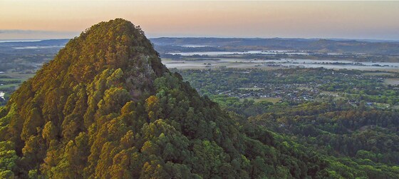
This is your chance to run or walk up Mt Chincogan, that ancient volcanic plug that overlooks Mullumbimby. It is on private land and not acessable at any other time.
Here is the link to the website where you register to race ( $50 ) or walk ($25 ) by August 31st. Late entries $75 ( if available ). This not a Club event, just a reminder that it is coming up. The Free Ticket below is to see if members would like to meet up and walk together- maybe a picnic lunch before the walk?
Questions to- Steve 0414312917
Sep
01
Ladakh, India: 4 Sep '26 Trek
01-09-2026 00:00 – 28-09-2026 02:00
This is NOT a classic trek. Classic treks = lots of people, lots of social media and lots of guide books and not much adventure or discovery to be had. This trekhas all the makings of a classic: mountains, rivers, huge sky, high passes, villages, monasteries, agriculture, people, wildlife, ancient petroglyphs and trekking in some of the most remote regions in the Himalaya – and of course the excellent service, great food and good company that we know Indian Himalayan Excursions is famous for – but without the other trekkers.
Dates: Leaving Australia 4 September. Number of days: 28Day 1 is flying into Delhi, Day 28 is flying from Leh to Delhi. Number of trekking days:20 Including rest days plus 2 day hikes from homestay
Number of trekkers:Minimum 6, maximum 12
Cost: $AUD4300
Included
All meals and snacks while on trek, ie from day 3-25
Tents and homestay accommodation
Sleeping bags and mattress
Staff (cooks, guides etc)
Porterage by horse
Hotels (double occupancy) in Manali and Leh
Transport from Chandigarh to Manali, then all vehicle transport until arrival in Leh at the end of the trek
Dinner and breakfast in Manali and Leh
Not Included
Lunch Manali and Leh
Tips
Any excursions outside of Leh on days 26 and 27
Flight Delhi to Chandigarh (approx. $60) and flight Leh to Delhi (approx. $200)
For the trek there is no extra charge for single supplement. Trekkers not wishing to share a tent will be accommodated at no extra charge.However there is a single supplement charge for hotels of $110. Single rooms are not likely to be available in the homestay in Kardang.
Day 1 Manali
Arrive Delhi airport, breakfast in the airport and then take the flight to Chandigarh (1 hour) We will be met at Chandigarh airport by IHE drivers and begin the drive of 6 hours to Manali. Our vehicles will be comfortable SUV style or if the group is at maximum, a bus. There will be plenty of rest stops enroute. Accommodation and dinner in Manali
Day 2 Manali
A day of rest and acclimatisation in Manali (2050 metres). Manali is IHE’s hometown. A small town easy to negotiate on foot to the market area, the Hadimba Temple, old Manali and the last chance to purchase forgotten items and eat city food.
Day 3 Kardang
From Manali the road climbs through conifer forest with massive Himalayan cedar to the entrance to the Atal tunnel. The tunnel cutting through the Himalaya is 9 kilometres long and is the longest tunnel in the world above 10000 ft. On the other side in Lahaul, the change in vegetation is marked – from forest on the south to a much drier landscape in the rain shadow of the Himalaya on the north. We turn west and 3 hours drive from Manali arrive at the homestay in Kardang village (3500 metres). An afternoon exploring the village, 900-year-old monastery and surrounds.
Day 4 Kardang
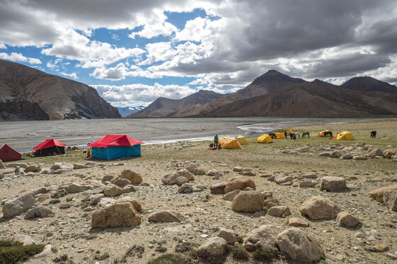
Our first acclimatisation hike is to the Gangstang Glacier, pictured below. We drive 1 hour from the homestay to the 17th century monastery at Shashur. It’s a steady climb through woodland and into alpine meadows: flowers and juniper and spectacular mountain views. We are likely to see Lahauli shepherds who bring their flocks to high pasture in summer. Our high point near the toe of the Gangstang Glacier is around 4000 metres.
Day 5 Kardang
Today’s hike is from Kardang on an ancient pilgrimage path which Hindu and Buddhist pilgrims follow in summer. The pilgrimage is to complete the kora (circuit) of the holy mountain of Drilbu Ri. The walk is through pea and barley fields into alpine meadows with huge views to Gangstang and across to Chandra River to Keylong and the Shikar Beh range. We reach 4450 metres at Khindang and our kora is completed with a jeep ride back to Kardang.
Day 6 Purne
After 2 good acclimatisation days we are ready to enter the high country of Zanskar and Ladakh. We drive over the 5100 metre Sinnku La into the southern Zanskar Valley and follow the Kargiak Chu (river) though severalsmallvillages to reach Purne, a tiny village at 3700 metres. At Purne the Kargiak Chu and the Tsarap Chu meet to form the Zanskar River which is a major tributary of the Indus River. In winter when the cold is intense and the passes are covered in impassable snow, the frozen Zanskar River, the Chadar is the only way for local people to travel through a frozen land.
Day 7 Phugtal Monastery
A 2 hour easy walk brings us to one of the most breathtaking sights of the trek.The 15th century Phugtal Monastery is built around a natural cave and appears to hang like a honeycomb from the cliff. The yellow hat monks of the Gelug school of Tibetan Buddhism are welcoming and we will spend the day exploring the monastery, especially to see the magnificent paintings and thankas. Camp today is at 3850 metres.
Day 8 Tantak
We follow the Tsarap Chu along a narrow track with a stream crossing near the village of Tantak. Tantak is an isolated, very small, traditionalZanskari village relying on marginal agriculture for its survival. We camp near the small monastery on the edge of the river at 4000 metres.
Day 9 Tantak
A rest day with a chance to visit Shade village at 4240 metres Shade is considered one of the most isolated and highest villages in India, “if not the world”. For 6 months of the year the 70 residents are cut off from the rest of the world when the extremely harsh winter arrives.
Day 10 and 11 Yarshun
We leave camp and climb gradually to NiyaloKhontse La. The 4820-metre pass offers magnificent views back to the Shade valley and ahead to Gotunda La and a beautiful alpine lake at the base of it. We descend to the base of Gotunda La and then climb steadily again to the pass at 5140 metres and a vista of peaks and glaciers as far as can be seen. We drop into a narrow gorge and pass though to camp at Yarshun at 4000 metres. Camp on Day 10 is flexible with a number of options depending on weather and the strength of the group.
Day 12 Satok
The magnificent Tsarap Chu is our constant companion today as we follow it through grazing meadows, crossing the Zara Chu on an improvised bridge before camp at 4010 metres
Day 13 Tsok Metsik
Another good day’s walk along the Tsarap Chu, easy walking with a number of small passes. Camp at 4000 metres
Day 14 Brandy Nullah
We reach the Manali to Leh highway early afternoon where our vehicles will be waiting to take us to camp near Gian. We camp alongside our old friend the Tsarap Chu at 4200 metres. We have left Zanskar and now inLadakh. The region we will be trekking in is called Changtang, the southern section of the vast Tibetan plateau.
Day 15Lamaguru
We follow the highly braided Tsarap Chu which has cut eroded banks in the most remarkable shapes. The earthy colours of the Changtangtwisted landscape are other worldly and it is a big day for photographers. We are now in Tibetan blue sheep (bharal) country and often see prints of snow leopard or wolf in the muddy riverbed. We cross the braided river a few times and camp at 4260 metres where the Umnag Chu meets the Tsarap
Day 16 Tsarap River Camp
Today is nature at its rawest with millions of years of geological time on display. The landforms are stunning, a backdrop to the clear, turquoise blue waters of the Tsarap. Fossilised shells are common, from a time when this was the ocean floor, 200 million years ago in Tethys time. We cross to the far bank and camp at 4550 metres.
Day 17 Pangpo La base
Straight out of camp we enter a narrow gorge which requires some rock hopping to negotiate the river that has cut it. The gorge narrows to be only a couple of metres wide with towering cliffs leading to soaring mountains above us. It then opens enough for us to camp on the edge of the river on grassy banks, a truly spectacular camp at 4850 metres.
Day 18 Kun Tso
This is a tough day for (hu)man and beast, a day when you marvel at the skill and toughness of the ponies and pony wallahs. Leaving our comfortable,relatively spacious river camp we re-enter the gorge often having to help establish the path for the ponies. When IHE pioneered this trek in 2016 the route had to be found and made – now the route is known but is so rarely used it is often blocked. We exit the gorge to a steep climb, a scramble for us and ponies but finally we reach more solid footing and the top of Pangpo La, 5239 metres. We follow a stream down and into the open valleys
of Rupshu to camp at 5000 metres near Kun Tso near a natural spring that gushes from the earth.
Day 19 Kun Tso
After yesterday’s effort a rest day is in order. Some will do that -rest -but others will be tempted to explore this amazing place. Every direction beckons the curious, the geology is remarkable, wildlife like Blue Sheep (bharal), Great Tibetan Sheep (argali), Wolf (shanku) and Tibetan Wild Ass (kyiang) have all been seen here on this rest day. The small lake Kun Tso is a magnet for bird life, especially Brahminy duck. At night it is a must to leave the warmth of your tent to see the stars like you have never seen before. Here at 5000 metres with clear air the stars and especially the milky way are memorable.
Day 20 Kyiang Shisha
We cross the valley floor in a circuitous route to visit some hidden sights; theArgali valley and the natural springs to camp at 4844 metres at KyiangSisha, the “Graveyard of the Kyiang” under a towering rock face. As with almost every day on this trek, those who feel they still have some walking left in them, have endless opportunity to explore from camp.
Day 21 Manechan
The valley opens up and the river is wide and braided. At times the river is above ground but mostly it’s below welling above ground in springs. We pass under Karpa with its unusually shaped summit and hanging glacier and cross
the Phirtse Phu to camp at 4680 metres on the grassy bank. The Phirtse Phu is the main feeder river to Tso Moriri, the lake we will reach in a couple of days. Kyiang are commonly seen and snow leopard were seen by an IHE group here in 2016 and their tracks on almost every trek.
Day 22 Kunmochey
We follow the Phirtse Phu, very pleasant walking along its grassy bank. Either side the walls are steep, and the valley closes the further we walk along it. Blue Sheep, marmot, kyiang, pika and fox are often seen and snow leopard and wolf tracks and kyiang bones, the remains of their prey, litter the valley floor. Wecamp at 4616 metres under ‘snow leopard cave’ which can be visited in the afternoon.
Day 23 Kyiangdom
This is a memorable day. We follow the Phirtse Phu to its end and climb above the river, turn the corner to the spectacular view of Tso Moriri with the highest peaks in Ladakh, the 6600 metre Chamser and Lamster Kangridominant across the lake. We drop to the lake but stop at the petroglyph site ‘discovered’ by IHE in 2016 and documented in 2018 (see Recommended Reading). Kyiang are common here as are the migratory bar-headed geese in Tso Moriri. Our camp at 4588 metres is nothing short of stunning:views across and down the lake, the Mentok peaks above camp and behind us in the distance the mountains of Spiti.
Day 24 Korzok
We walk the length of Tso Moriri admiring its many colour changes but at times cursing the wind if it is blowing and the deceptive distance. But all things must end and we reach the tiny village of Korzok at 4600 metres, a monastery and a road. This is civilisation, the end of the trek.
Day 25 Leh
Like all drives there will be times when you wish the drive to Leh was over. But do take in the spectacular scenery, remember you are seeing the mighty Indus, one of the world’s great rivers and in a short time you’ll be enjoying a hot shower and perhaps a strong coffee and cake at one of Leh’s many coffee shops.
Days 26 and 27 Leh
Leh is a wonderful place to wander in, visit the old fort, Shanti Stupa, the Muslim bakeries, do some shopping, observe life on the Mall, have yet another coffee and cake. There are also some great day trips from Leh;
Hemis and Thiksey Monasteries or even a day’s rafting on the Indus. IHE has excellent contacts in Leh and anything can be arranged.
Day 28 Delhi
The flight to Delhi is reliable and many will choose to fly Leh to Delhi and take their international flight the same day. Make sure you get a window seat as the Leh to Delhi flight must be one of the most amazing flights in the world.
Recommended reading
Wild Places Wild Hearts Nomads of the Himalaya by Allen Smutylo 2007
The best book I have read of the Changtang and a beautiful coffee table book well worth owning
Ancient Futures by Helena Norberg Hodge 2009
Cultural change in Ladakh
A Journey in Ladakh by Andrew Harvey 2003
The link below is to a paper written by Bill Boyd when we ‘discovered’ an extensive site of Buddhist and pre-Buddhists petroglyphs near Tso Moriri in 2018
More info: Stephen Millard 0414 312 917
Oct
16
Minyon Falls- Thur Oct 16
08:00 – 12:00
The walk from the wet sclerophyl forest at the top to the dense cool rainforest at the base of the Falls gives a great transistion betwen the two extremes. Opportunity for a swim at the bottom and a picnic lunch at the finish.
Grade 3, Leader Kerrie, 0432 872 148
Oct
18
Paddle Tuckean Nature Reserve Sunday October 18
Bagotville
09:00 – 12:00
We will paddle through the nature reserve along canals covered with water lilies. The vegetation is dominated by large paperbarks and swamp oaks which become inundated in wet weather.
This is a great paddle for bird enthusiasts with ducks, black swans, whistling kites, pelicans, royal spoonbills and the shy comb-crested jacanas to be seen. Binoculars assist.
Parking is limited so car pooling recommended - list of participants to be sent.
Grade 2, 5km plus - depending on how paddlers are feeling, there are plenty of canals to explore.
Leader Sandy 0415 239 620 sandylpimm@gmail.com
You will need your own kayak for this one as all the spare kayaks are booked.
Sep
01
2027
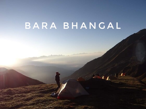
Indian Himalayan Grand Shepard's Traverse Trek - Sep '27
Manali
01-09-2027 07:00 – 26-09-2027 09:00
Departure Sept 1
From Manali (2200m) we begin with a short trek in the mountains surrounding the beautiful Kullu Valley to acclimatise to higher altitudes, and then follow the Grand Shepherd’s Traverse from Kullu to Kangra Valley. The trek is through one of the most remote corners of Himachal Pradesh, following an ancient and remote shepherd’s trail between the Kullu and Kangra Valleys. Beginning in dense forests and alpine meadows above Manali, the trek crosses the KaliHind Pass to the ancient Gaddhi village of Bara Bhangal in Kangra, the most scenic valley in Western Himalaya. Each trekking day is a delight with tremendously varied landscapes and a great variety of Himalayan flora and the possibility of seeing fauna such as brown bear, black bear, fox, snow leopard, musk deer, monkey and the Giant Indian Flying Squirrel. On the trek we pass through remote Gaddhi villages isolated by heavy snowfall for most of the year. There are spectacular views of the rugged Dhauladhar Range especially crossing Thamsar Pass but then on descent, another world; a softer landscape of meadows, forests and the cascading waterfalls and tiny villages hanging on the sides of the mountain slopes. We finish at Bir, a small Tibetan village with a monastery. From Bir we drive to Dharamsala, the home of the Dalia Lama and the Tibetan Government in exile. Book a 'ticket' below as an expression of your interest and phone Steve to express this interest 0414312917
Past events
Jul
26
Past Event
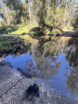
Rocky Creek Dam Circuit Walk - Sunday 26 July
Rocky Creek Dam
08:30 – 12:00
Start your Sunday morning with a fast paced walk amongst the established rainforest of Rocky Creek Dam and Nightcap National Park. We will walk up along the Scrub Turkey track to Gibbergunyah Range Road firetrail and circle back around crossing Rocky Creek and on through open pasture to return to the picnic ground.
Bring along a thermos and snack for some morning tea by the reflections of the water.
Expect wet feet to cross the creek but it is easy to take your boots off. Allow 2.5 hours as the walk itself is approx. 11km. Please meet at 8.30 at the Rocky Creek Dam carpark. (Grade 2/3)
Leader: Libby 04289387352
Jul
18
Past Event
Salty Lagoon walk Saturday 18 July in Broadwater National Park
10:00 – 13:00
The route follows the hind dune trail to Salty Lagoon, an ICOLL where you may spot Black-necked storks or other waders. Broadwater is a refuge for migratory shorebirds, a hunting ground for birds of prey and habitat for a broad range of birds that inhabit the park's various plant communities. These include threatened species such as pied oystercatchers, little terns and beach stone curlews. White-bellied sea eagles can also often be seen trawling the coastline. we will return along the beach.
This is the peak season for northern migration of whales, in case you haven't caught them yet this year.
We will meet at the end of Broadwater Beach Road and have a quick look at Broadwater Beach Lookout to marvel at the size of the sand dunes formed thousands of years ago.
Easy Grade 2 walk.
Leader Sandy 0415239620 sandylpimm@gmail.com
Jul
12
Past Event
Postman's Tree Sun Jul 12
Huonbrook Road
09:00 – 16:00
We meet in Wilsons Creek and then hike through the Doon Doon Saddle to the Tea Tree lookout with its sweeping views over an ancient volcanic plug, Mt Woolumbin, and the Border Ranges. We ascend along the historic Nightcap Track, past the famous Postman's Tree, past the second camp in the new Gidgum Gulganyi 4-day trail and then returning down North Rocks Rd. We ascend and descend about 500 vertical metres. This is planned as a workout for some of our members who are trekking for a month in Ladakh, India, in September but everyone is welcome. Grade 3 - 4. Leader Steve 0414312917. Assistant leader Ginette 0402171883
Jul
10
Past Event
Club Social Night & Member Presentations
2/59 Centennial Cct
18:00 – 21:00
Byron Hikers Social Evening
Please join us for an informative and supportive exchange of all things hiking.
A night to welcome newcomers to the club and a chance for current members to gather without their packs.
This month we will hear from two longstanding members about their separate journeys throughout the summer months.
Bob Brockhill will talk about an adventurous
Three Weeks in the Snowies and
David Roland will present
Walking the Bundian Way - From Summit to Sea.
A journey along one of Australia's most significant cultural walking routes, tracing an ancient pathway from the high country to the coast.
Please bring along a plate of food to share and your own drinks .A folding chair would also be useful if you have one.
We will be gathering at 6pm and presentations will commence from 7pm .
Venue : 2/59 Centennial Circuit, Byron Bay (Just opposite Reece Plumbing)
All members and guests welcome
Jul
04
Past Event
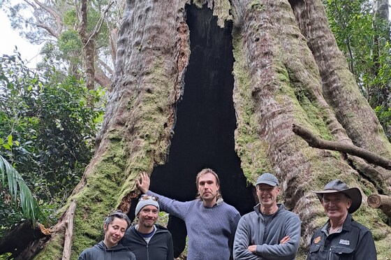
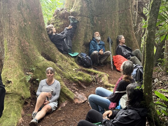
Forest Bathing walk to 1000 year old tree - Saturday 4 July
The Pocket
08:30 – 14:00
Join us for a special event, a forest bathing walk to a 1000-year-old tree on private property at The Pocket, culminating in spectacular views towards Byron Bay. We last did this walk with Timothee, who hosted us in recent years and the new owner of the property has invited us back. How lucky are we!
The walk begins at the house and ascends a hillside through regenerated and ancient forest. By lunchtime, we will reach the top of the hill where breathtaking views await.
More details to come.
Grade: 3
Distance: approx. 4 km
Leaders: David Roland and Cass Emanuel
Enquiries: david@davidroland.com.au
Jun
28
Past Event
Mt Jerusalem via Blue Lagoon & Wild Dog Rd Sun-Mon 28,29 Jun
Upper Wilsons Creek
28-06-2026 08:00 – 29-06-2026 16:00
We are going off-track from Upper Wilsons Creek, past the Blue Lagoon, up the Rockslide to the Byron Hikers camp at the headwater of the Wilsons River (that floods Lismore). Our camp is on the intersection of the new path over Mt Jerusalem. On Monday we go over Mt Jerusalem on part of the new 4 day Gidjum Gulganyi trail, visiting The Arch and then return to the cars via Wild Dog Rd which the Club cleared last year. We will be meeting in Wilsons Creek at 8am. Grade 4, leader Steve 0414312917